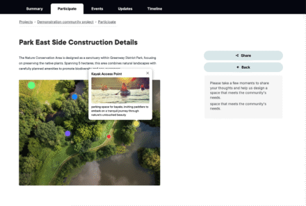
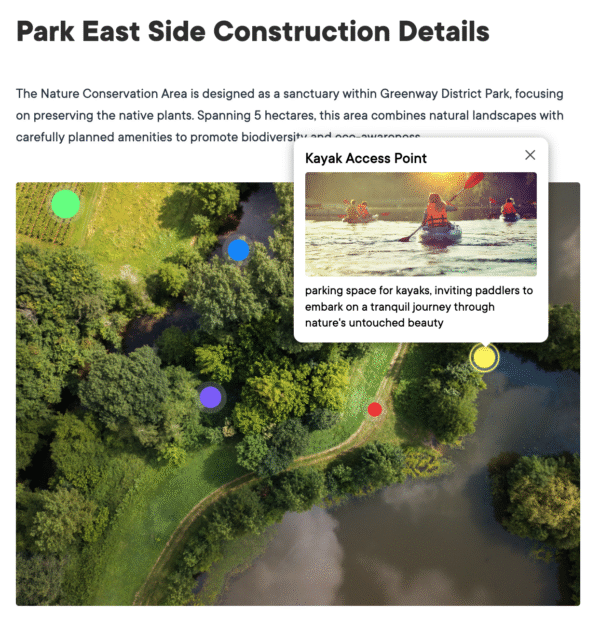
Hotspot Tool

Bring your visuals to life with hotspots.

Turn static maps and plans into explorable content. Add interactive points that reveal info, feedback forms and links with ease.

Information panel detailing Park East Side construction project with kayak access point.

Bring clarity to complex visuals through simple, interactive exploration

The Hotspot Tool is Civio’s visual communication feature, enabling you to add interactive elements to images and plans. It transforms static visuals into explorable content with clickable points that reveal detailed information.

Make complex information more accessible and engaging, helping your community understand detailed plans, designs, and concepts through intuitive visual interaction.

Benefits

  • Visual explanation: Communicate complex information in an intuitive, accessible way
  • Engaging exploration: Encourage active discovery through interactive content
  • Focused feedback: Collect input on specific elements of visual materials
  • Reduced complexity: Break down detailed information into manageable pieces
  • Enhanced understanding: Help people grasp spatial relationships and design details
  • Accessible information: Make technical content more approachable for all audiences

Content, Linking and Participation

  • Insert rich text, downloads and links to related activities
  • Invite comments on specific hotspots to focus discussion
  • Add quick questions or connect to surveys for structured feedback
  • Direct people to registrations, updates or pages for deeper engagement.

Display and Accessibility

  • Customise icons, colours and labels to group hotspots by theme or stage.
  • Enable numbering or clustering to guide exploration and keep views clean.
  • Allow zoom and pan for detail on both desktop and mobile.
  • Responsive layout, keyboard navigation and descriptive text ensure accessibility.
  • Optimised image handling for fast loading and smooth interaction.
Overview of a nature conservation area with water bodies and green landscapes.

Practical Applications

Local government

A city planning department can add interactive hotspots to proposed park designs, allowing community members to click on different features to learn more about materials, accessibility considerations, and maintenance plans.

Two women sitting at a round concrete table in a park, engaged in conversation.

Healthcare

A hospital can create interactive floor plans of a new facility, enabling patients and staff to explore different areas and provide specific feedback on room layouts, wayfinding, and amenity placement.

An elderly couple smiling while holding cups on a porch railing.

Transport & Infrastructure

A transit authority can develop interactive station designs with hotspots explaining accessibility features, amenities, and connection points, collecting targeted feedback on specific elements that matter most to different user groups.

A city intersection featuring traffic lights and a bus in motion amidst tall buildings.

Arts and Culture

A museum can implement interactive exhibition layouts where community members can explore proposed displays, learning about content themes and providing input on interest levels and educational value.

Visitors in a gallery looking at abstract artwork displayed on the walls.

Urban Planning

A planning agency can create interactive streetscape designs with hotspots explaining proposed changes to traffic patterns, pedestrian areas, and green spaces, helping residents understand and comment on specific elements.

A person pointing at a digital map on a tablet while another person points at a paper map during an urban planning discussion.

Plans designed around you

Explore our plans and request pricing. We’ll send you a clear proposal, no sales calls, just the details you need.

A woman with curly hair and headphones looking at a tablet in a brightly lit corridor.