Visualise community input spatially to understand location-based needs and opportunities
Spatial Engagement tools help you collect and understand feedback in its geographic context. They make it easy to see how community input, needs, and ideas relate to specific locations and areas.
With Civio’s Spatial Engagement features, you can create rich, interactive maps that help your community provide location-specific input and help you visualise patterns that might otherwise be missed.
Key Benefits
- Geographic understanding: See exactly where community concerns and ideas are concentrated
- Visual patterns: Identify clusters and trends across your community’s geography
- Contextual insights: Understand feedback in relation to physical features and boundaries
- Intuitive interaction: Provide an accessible way for people to share location-based knowledge
- Targeted planning: Focus improvements and interventions where they’re most needed
- Spatial storytelling: Communicate plans and options through compelling visual maps
Engagement Solutions
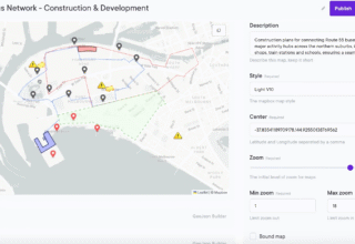
Map Builder
Turn maps into engagement tools.
Go beyond static geography by adding interactivity, detail and feedback so your community can explore what matters most.
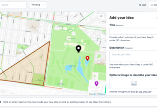
Map Ideation
Place ideas directly on a map to capture local knowledge with context.
Community members can share, discuss and refine proposals tied to real locations.
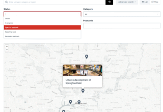
Project Map Search
Find and explore consultation projects in your area through location-based search.
Set project locations so people can quickly see what is happening nearby and engage with projects that matter to them.
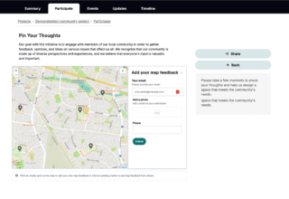
Map feedback
Collect location-specific input through interactive maps that allow participants to place pins, complete geographically based surveys and provide comments.
Map Feedback helps visualise community input spatially to understand location-based needs.
Practical Applications
Local government
Planning departments can create interactive maps showing proposed development areas, allowing residents to provide location-specific feedback about traffic concerns, environmental considerations, and design preferences.

Transport & Infrastructure
Transit authorities can collect route-specific feedback through map tools, enabling riders to indicate exactly where service improvements are needed or where accessibility challenges exist.

Environment
Conservation agencies can use spatial analysis to identify priority areas for environmental initiatives based on community input, helping target resources where they align with both ecological needs and community values.

Public Safety
Emergency management teams can gather community input on evacuation routes and safety concerns, creating more effective emergency plans based on local knowledge of potential hazards and gathering points.

Parks and Recreation
Parks departments can collect location-based feedback about facility needs and maintenance issues, helping prioritise improvements based on actual usage patterns and community preferences.

Related Features
See why agencies are moving to Civio
Discover the platform helping government agencies achieve stronger engagement, with tools that save time and simplify administration.