Map Ideation

Place ideas directly on a map to capture local knowledge with context.

Community members can share, discuss and refine proposals tied to real locations.

User interface displaying a map with an option to add ideas at Civio's platform.

Turn community input into place-based innovation with an interactive map

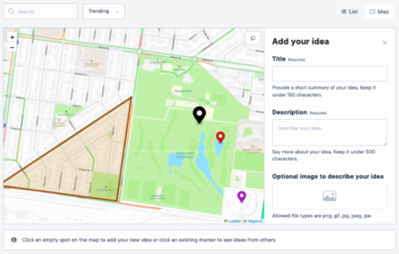
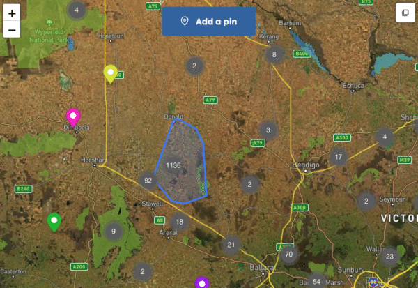
Map Ideas is Civio’s spatial brainstorming tool, allowing your community to submit, discuss, and develop ideas directly linked to specific locations. It provides a visual platform for innovation, connecting creative thinking with geographic context.

With Ideas, you can tap into your community’s collective intelligence to address location-specific challenges, uncover place-based opportunities and create innovative solutions that cater to the unique characteristics of different areas.

Benefits

  • Contextual innovation: Generate ideas that respond to specific geographic conditions and needs
  • Visual collaboration: Enable community members to see and build on each other’s location-based suggestions
  • Spatial patterns: Identify clusters of similar ideas that reveal priority areas for attention
  • Targeted solutions: Develop innovations tailored to the unique characteristics of different locations
  • Inclusive participation: Provide an intuitive way for people to contribute local knowledge and creativity
  • Resource optimisation: Focus improvement efforts where community ideas show the greatest potential impact

Spatial Idea Submission

  • Place ideas on a map with points, lines or areas
  • Add text, images, categories and tags
  • Allow anonymous or identified submissions
  • Cluster and filter ideas to spot location patterns
  • Group ideas under themes to show priorities
  • Track contributions and participation levels
  • Discuss ideas with threaded comments
  • Vote on proposals to show community support
  • Link map ideas to surveys, events or updates
User interface displaying a map with an option to add ideas at Civio's platform.

Map Visualisation

  • Cluster ideas in high density areas
  • Choose from custom base map options
  • Toggle layers for focused viewing
  • Use maps that work seamlessly on mobile

Idea Management

  • Review submissions in an admin dashboard
  • Filter and select ideas by location
  • Apply bulk actions to similar ideas
  • Post official responses to community input
  • Export ideas into planning systems
Map of Victoria, Australia showing various geographic markers and locations.

Practical Applications

Local government

A city planning department can engage residents in reimagining underutilised public spaces by enabling them to place ideas directly on a map of potential locations, allowing community members to suggest specific amenities that would work well in particular spaces based on the surrounding context and neighbourhood needs.

Two women sitting at a round concrete table in a park, engaged in conversation.

Transport & Infrastructure

A transit authority can collect innovative ideas for improving the cycling network by having riders mark specific intersections, routes, or areas where they envision new infrastructure solutions, generating location-specific innovations that address the unique challenges of different parts of the network.

A city intersection featuring traffic lights and a bus in motion amidst tall buildings.

Parks and Recreation

A parks department can gather creative suggestions for park improvements by enabling visitors to place ideas directly on maps of different parks, helping identify which features would work best in specific locations based on existing amenities, natural features, and usage patterns.

People gathered on grass in a city park near a river with skyscrapers in the background during sunset.

Urban Planning

A planning agency can engage the community in neighbourhood revitalisation by using map ideation to collect location-specific ideas for vacant lots, building reuse, and streetscape improvements, creating a community-generated vision that respects local character and needs.

A person pointing at a digital map on a tablet while another person points at a paper map during an urban planning discussion.

Environment

A conservation organisation can collect innovative approaches to environmental challenges by having community members mark locations where they've observed issues and suggest solutions specific to those areas, leveraging local knowledge to develop targeted interventions.

Aerial view of a meandering river flowing through a landscape with contrasting colors.

Plans designed around you

Explore our plans and request pricing. We’ll send you a clear proposal, no sales calls, just the details you need.

A woman with curly hair and headphones looking at a tablet in a brightly lit corridor.